Scott Reinhard Maps Yellowstone National Park
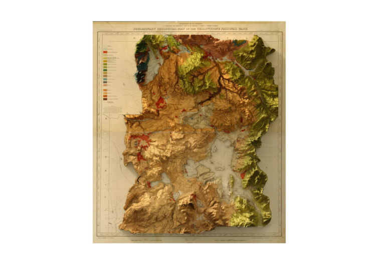
Scott Reinhard is well-known for combining historic maps with contemporary land elevations. This results in stunning three-dimensional environments that elevate the way we see and appreciate traditional maps. And for the fans of the Yellowstone National Park, Reinhard is offering a spectacular piece of 3D map of the famous park.
The Yellowstone National Park boasts of the geological map that the US Geological Survey conducted in 1878. It remains faithful to Reinhard’s philosophy of utilizing only historical maps in his creations. This provides a very realistic 3-dimensional elevation of the famous park. He then has the 3D map printed in 2D format to provide you with a different and unique perspective.
The map accounts for every mountain, hill, river, and crevice on the Yellowstone landscape. Reinhard uses traditional color photography development instead of the more contemporary digital development. Reinhard’s chromogenic printing know-how is a testament to his skill. This adds more value to the map as it conveys a feeling of authenticity.
Looking at the Yellowstone National Park map, one cannot help but feel awe. This is a masterpiece that can only come from one of the world’s best graphic designers and topography artists. Reinhard’s keen attention to detail is astounding, to say the least. The way the map gets printed is extraordinary. You don’t get a map this detailed.
It is as if you are looking at a satellite image of this famed national park. The geological features are indeed breathtaking. It seems as if the whole park is beckoning on you to visit it at the soonest possible time.
The Yellowstone National Park map from Scott Reinhard is a true gem. It’s a classic that is perfect on the walls of any modern home or office. It can also be a wonderful gift for someone who loves the park.


